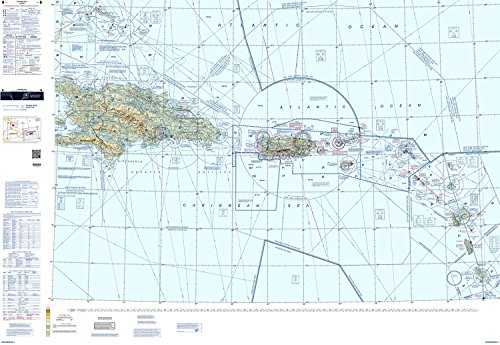
Explore the Caribbean with Confidence
Introducing the Caribbean VFR Aeronautical Chart, specifically designed for FAA pilots looking to navigate the stunning landscapes of the Caribbean. Whether you're planning a leisurely flight across the crystal-clear waters or embarking on a professional journey, this aeronautical chart is your ultimate companion. With comprehensive coverage, accurate depictions of geographic features, and key navigational information, it ensures a smooth and secure flight experience.
Unmatched Accuracy and Detail
Our Caribbean VFR Aeronautical Chart sets a new standard in precision and reliability. Developed by aviation experts and FAA-certified cartographers, every detail is meticulously researched and verified, guaranteeing unparalleled accuracy. From airports and heliports to airspace boundaries and communication frequencies, this chart provides extensive information to enhance your situational awareness, making navigation effortless and enjoyable.
A User-Friendly Navigational Tool
Designed with the needs of FAA pilots in mind, this chart offers user-friendly features to facilitate navigation. Clearly marked visual waypoints, including VORs and NDBs, enable easy route planning, while detailed airport diagrams assist in safe and efficient landings. From popular tourist destinations to remote island airstrips, this aeronautical chart covers it all, empowering you to explore the Caribbean with utmost confidence and peace of mind.